Hardware logger
| Deutsch | English |
|---|
| Water depth |
|---|
| Depth-Website |
| The project |
| Measuring strategy |
| Upload NMEA-data |
| Metadata help |
| Connecting NMEA-Logger |
| Hardware Logger |
| Software Logger |
| Mobile sounder |
| Ship network |
| Data formats |
Some chart plotters and other navigation tools are able to log water depths in a native way.
In order to do this, some chart plotters have an integrated SD-chart-slot and write the data direcly to the SD-chart,
other plotters use an USB-, LAN-, or WLAN-interface and can be connected directly to a laptop.
It is crucial that the output data include at least the GPS position, the GPS time and date, and the water depth.
For all other plotters:
- NMEA-2000
For NMEA-2000 plotters or Seatalk-NG plotters you can use the 2K-Logger.
- NMEA-0183, Seatalk-01
For all plotters with NMEA-0183-interface or for all Seatalk-01 plotters you can use the OpenSeaMap 2-channel logger.
Alternatively you can connect the logger directly to a sounder and a GPS device.
Inhaltsverzeichnis
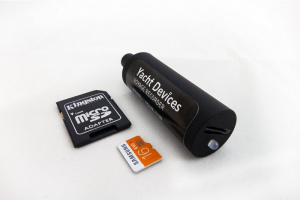
OpenSeaMap 2k-Logger
The commercial 2k-Hardware-logger are available in two versions from Busse-Yachtshop:
| NMEA-2000 | 189 € | order... |
| Seatalk-NG | 189 € | order... |
The small device looks lika an USB-charger for cars. You can simply connect it to your bus system.
A Micro-SD-card stores your voyage data for about 200 days with 32 GB.
The data can be filtered and analysed by software as you wish.
You can upload the depth data from your PC directly to our server at depth.OpenSeaMap.
Datasheet (English)
Manual (English)
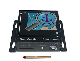
OpenSeaMap NMEA-0183 Logger
You can order our hardware-logger for 30 € (cost price).
This logger is available in two versions:
| 2 channels with NMEA-0183 | 30 € | order... |
| channel A with NMEA-0183 channel B with Seatalk-01 incl. Seatalk-adapter |
50 € | order... |
The data will be stored on a SD-chard.
Power 12 V, max. consumption about 150 mA.
In addition, the device includes a Gyro and accelerometer.
With this we get an information about waves and ship movements.
The corresponding GPS- and sounder-data are stamped with an internal milli-second clock so that we can connect them correctly.
Manual, with installation guide
Developer page
Device list
With this devices from Raymarine, Lowrance, Garmin, Hummingbird, B&G und Simrad you can log waterdepths directly:
Bitte melde weitere Geräte. Tests und Tips sind immer willkommen :-)
| Manufacturer | Type | Model | ok | tested | Aoutput | Format | Remarks |
|---|---|---|---|---|---|---|---|
| Weatherdock | AIS | easyTRX-2 A034 | SD | NMEA-0183 | if sounder and GPS are connected via NMEA | ||
| Weatherdock | AIS | easyTRX-2 IS A050 | SD | NMEA-0183 | if sounder and GPS are connected via NMEA | ||
| Lowrance | Plotter | HDS7-Gen2 | ? | NMEA-0183 | mit eingebautem GPS und Echolot | ||
| Raymarine | AIS | AIS 650 | SD | if sounder and GPS are connected via NMEA | |||
| Raymarine | Plotter (MFD) | C-wide E-wide C/E classic |
SD | FSH | if sounder and GPS are connected via NMEA | ||
| Raymarine | Plotter (MFD) | new a-series new c-series new e-series |
microSD | FSH/GPX | if sounder and GPS are connected | ||
| Raymarine | Plotter | c127 | MicroSD | FSH | |||
| Raymarine | Plotter | div. | MicroSD | SDF | Lighthouse II, R10 or newer needed | ||
| Raymarine | Display | ST70 Multidisplay | MicroSD | NMEA-0183 | HW- oder SW-Logger erforderlich | ||
| Garmin | Plotter | EchoMap-Serie | SD | ADM | with built-in GPS and sounder | ||
| Garmin | Plotter | GPSMAP 420 | SD | ADM | if sounder and GPS are connected | ||
| Garmin | Plotter | GPSMAP 420s | SD | ADM | if GPS connected | ||
| Garmin | Plotter | GPSMAP 520 | SD | ADM | if sounder and GPS are connected | ||
| Garmin | Plotter | GPSMAP 520s | SD | ADM | if GPS connected | ||
| Garmin | Plotter | GPSMAP 526 | SD | ADM | if sounder and GPS are connected | ||
| Garmin | Plotter | GPSMAP 526s | SD | ADM | if GPS connected | ||
| Garmin | Plotter | GPSMAP Touch | SD | ADM | if GPS connected | ||
| Humminbird | Plotter | all with "Precision GPS" | SD | SON | |||
| B&G | Plotter | Zeus | if sounder and GPS are connected | ||||
| B&G | Plotter | Zeus2 | if sounder and GPS are connected | ||||
| B&G | Plotter | Zeus Touch | if sounder and GPS are connected | ||||
| Simrad | Plotter | NSS | if sounder and GPS are connected | ||||
| Simrad | Plotter | NSO | if sounder and GPS are connected | ||||
| Simrad | Plotter | NSO evo2 | if sounder and GPS are connected | ||||
| Simrad | Plotter | NSE 8 | if sounder and GPS are connected | ||||
| Simrad | Plotter | NSE 12 | if sounder and GPS are connected | ||||
| NASA Clipper | Display | Clipper Depth | + Arduino! | NMEA-0183 | see "NASA_Clipper_Range and Arduino" | ||
| ... | |||||||
| ... |
Only with Multiplexer usable devices
With this devices you need an additional Multiplexer:
| Hersteller | Typ | Bemerkung |
|---|---|---|
| Weatherdock | alle WLAN-AIS-Geräte | external Multiplexer needed |
Self-made solutions
- WLAN-NMEA-0183 mit TP-Link (Victor)
- NMEA-0183-HW-Logger with Arduino (Matthias Busse)
- WLAN-NMEA-2000-HW-Logger with Raspberry Pi (Victor)
- ...

