OpenSeaMap-dev:Watersport-Wiki
| Deutsch | English |
|---|
The project "Watersport-Wiki" shall provide semantic information for sailors, divers, canoeists and other water sports enthusiasts and link them directly to the geodata on the map.
Inhaltsverzeichnis
So far
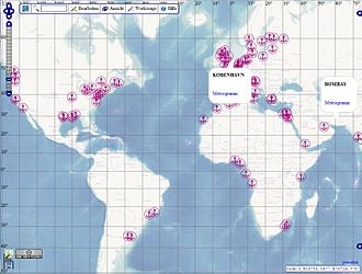
Since 2010, ports, marinas and anchorages in the Port Layer are displayed as magenta icons ![]() .
. ![]() shown on the map. The data come from different and inconsistent sources (SG, WPI, OSM) with different class structures. A popup shows the name and, where available, a link to SkipperGuide, our Wiki Harbour Guide. difficulties with SkipperGuide: missing internationalization, data cannot be edited on OpenSeaMap, synchronization is problematic.
shown on the map. The data come from different and inconsistent sources (SG, WPI, OSM) with different class structures. A popup shows the name and, where available, a link to SkipperGuide, our Wiki Harbour Guide. difficulties with SkipperGuide: missing internationalization, data cannot be edited on OpenSeaMap, synchronization is problematic.
Since 2011, 1.7 million Wikipedia articles are linked directly on the map, optionally also as a picture gallery.
New structure
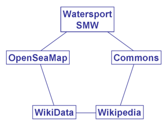
To avoid reinventing the wheel, we use the experience of the WikiMedia-Foundation. As with Wikipedia and the Harbour Handbook, the objects are described in a Wiki, with continuous text, images and data. For each language we use a MediaWiki. The images are stored in Wikimedia-Commons, and from there they are directly integrated into the Wiki. Data (place names, number of berths, contact data, website, technical data, etc) will be included in Wikidata (WD). From there, the data can be integrated directly into the Wiki in a uniform manner across languages.
Images can be integrated directly from Commons.
Wikipedia articles can be integrated directly from Wikipedia or Wikidata.
Users and contents
| User | Contents | Articles |
|---|---|---|
| all | sailing areas | 50 k |
| Sport boat drivers | harbours, marinas, anchorages, shipyards, gas stations | 20 k |
| Divers | Dive sites, rental stations, tank filling stations, diving schools, diving ships (mooring) | 100 k |
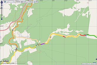
| Kayakers | river hiking routes, whitewater routes, obstacles, levels of difficulty, rental stations | 10 k |
| Fishermen | Fishing grounds, fish species | 10 k |
| all | Lights, Pictures | 40 k |
| all | Wikipedia articles, WIWOSM | 50 k |
| ... |
Multilingual
As required for an international project, it should be possible to take all languages into account. We start with German and English. Follow-ups should be French, Spanish, Portuguese, Italian, Russian, etc., as required. Any other languages are possible. Each language is represented in its own Wiki. This allows the authors to write the content for the articles in their own language freely and independently of the other languages. Nevertheless, the data is consistent across languages, as it can be centrally integrated from Wikidata.
Place names on the chart
Names of cities and ports must be readable by the map user in his writing.
At the same time, the name of the town or city must be readable by the resident.
Only in this way is mutual understanding possible on site.
See also OSM Key:name
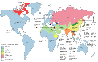
So we need a chart with duplicate place names for each of the major writing systems (Latin, Chinese, Cyrillic, Arabic):
- Place name, as it is written in the local region (writing system of the region)
- Place name, as the map user writes and can read it (user's writing system)
Alternative
- Place name, as it is written in the local region (writing system of the region)
- LOCODE as international Latin spelling (see LOCODE list)
Implementation
- a) different cards
- b) switchable name layers
Transcription
Names of countries and cities are always written as Endonym, i.e. the way the country is called by the inhabitants of the country they refer to.
Transcription is the correct 'onomatopoeic translation of place names (or general terms) from one language to another.
Transliteration
Attention: Transliteration only allows a correct sortability of names, e.g. in databases and lists.
Transliteration [1]
Simple gadget to provide transliteration available on pywikibot on Wikidata items sitelinks example
Workflow
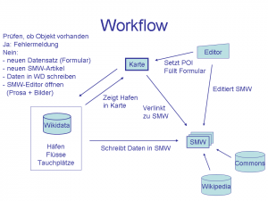
The central medium is the 'online map of OpenSeaMap. On the corresponding layers, currently Harbour Layer and Sport Layer, all relevant objects appear as clickable icons:
- Harbours, marinas, anchorages,
- Kayak routes
- Diving areas
- associated POIs
When clicked, a Popup opens with:
- Name
- Picture
- Link to Wiki article
- Meteogram
- if necessary, other relevant data (water gauges)
- if necessary, further images (water gauge graphic)
- Editor for the Wiki page
The wiki page is edited with a special Wiki Editor directly from the sport layer. The editor is directly linked in the object popup. The wiki editor is similar to the well-known MediaWiki editor, but is more user-friendly (Wysiwyg) and performs various data checks in OSM and Wikidata.
A new click object is generated with a special Wiki Editor. It checks if a corresponding object already exists in the OSM DB, if not, it creates one. If an OSM object exists, the system checks whether an entry for it already exists in Wikidata; if not, a WD item is created. If a WD item exists, the Wiki article is opened for editing.
News
- 1.9.2012
- Lecture about water sports Wiki at the WikiCon
- followed by a meeting with project management Wikidata and SemanticMediawiki specialists
- 17.8.2012
- Presentation of the project at the developer meeting
Olaf and Mario work at the Hafen-DB
- 4.6.2012
SG can now distinguish between ports, marinas, anchorages and sailing areas
- So far
- since spring 2012 discussions with the University of Karlsruhe, SMW specialists and Wikidata
- since 2011 several attempts to merge the Hafen-DB
- since 2010 attempt to edit the ports on the map and synchronize the data with SG
Technique
Sports Layer
Sport layers and Port layers show POIs as icons, river routes as lines and areas as surfaces.
Above this is a transparent layer that provides the click function.
(currently the icons are directly clickable, lines and areas do not work yet)
Port DB
The OpenSeaMap-dev:Harbour-DB currently consists of 3 tables, and OSM has another one.
The tables are currently being consolidated, OSM data is to be incorporated.
This data can then be transferred to Wikidata.
Synchronization with OSM-DB
In the OSM-DB also ports, marinas and anchorages are entered (node, area).
Also dive sites (node, way, area) and white water sections (way).
| This data must be synchronized with Wikidata... |
Software
Wikidata is currently being used: (8.2012)
MediaWiki 1.20alpha (1761192) PHP 5.3.2-2wm1 (apache2handler) MySQL 5.1.63-0 ubuntu 0.10.04.1
Login
A single login would be ideal for:
- OpenStreetMap
- Wikidata
- Water Sport Wiki
Hardware
Maybe by MW-DE? or Manuel?
Wiki Editor
The well-known MediaWiki Editor, supplemented by special Wikidata functions, serves as the Wiki Editor in the first stage of expansion.
In the medium term, various data checks for OSM and Wikidata will be added based on this.
Zoom level
Depending on the meaning of the objects, they appear at different zoom levels:
| Object | at zoom level | Remarks |
|---|---|---|
| Port large | 1 | should only be used from z=4 |
| Port medium | 7 | |
| Port small | 8 | |
| Harbour very small | 9 | |
| Marina | 10 | |
| Anchorage | 11 | |
| Kayak route | 9 | |
| Kayak POI | 14 | |
| canoe rental | 14 | |
| Dive site | 14 | |
| Swimming pool | 14 |
Data model
Harbour
Further "port ideas" can be found in the OSM-Wiki [2]
| Key | Value | Format | Remarks |
|---|---|---|---|
| ID | Key | ###### integer | incremental |
| WPI-No | ###### integer | only available for ports from WPI | |
| LOCODE | AAAAA | only for bigger locations known | |
| class | harbor / marina / anchoring | ||
| size | large / medium / small / very small / little | l.m.s,vs is part of WPI, li is for SG may be "li" needs smaller steps, or subset | |
| name | string | international spelling as in WPI without diacritics. Examples: "Lubeck", "Hong Kong", "Copenhagen" | |
| name_endonym:xx | string | endonymous notation, "xx" is the abbreviation for different writing systems. Examples: "Lübeck", "Hong Kong", "Køpenhaven" in Latin script | |
| name_official | string | with all name affixes in national script | |
| name_local | string | national spelling in national script. Examples: "Lübeck", "香港", "København" | |
| category | RoRo / fishing / ferry / bulk / container / straddler_carrier / syncrolift / passenger | quite a mess... | |
| operator | string | ||
| harbour_master | string | with a subset "hm" | |
| hm_phone | +### #########-######## | international format | |
| hm_VHF | ## | VHF channel | |
| hm_MMSI | ########### integer | MMSI number | |
| ... |
Diving
For divers, we need more data...
Canoeing
For canoeists we need more data...
