Suchergebnisse
Erstelle die Seite „Depth Data“ in diesem Wiki. Siehe auch die gefundenen Suchergebnisse.
- [[OpenSeaMap-dev:De:Depth raw data|Tiefendaten (1.)]] und (2.2) werden als Datei auf den Server hochgeladen. [[OpenSeaMap-dev:De:Depth meta data|Metadaten]] (3) werden über ein Formular auf den Server hochgeladen.5 KB (611 Wörter) - 07:25, 19. Feb. 2021
- * https://depth.openseamap.org - frontend depth projekt * https://depth.openseamap.org/org.osm.depth.upload - backend depth projekt1 KB (192 Wörter) - 14:20, 9. Nov. 2023
- ! Depth || Special Order || Order 1A || Order 1B || Order 2 : rules and mechanisms employed for data thinning7 KB (892 Wörter) - 07:17, 19. Feb. 2021
- …en an die Datenbank. Die Rohdaten werden dann so [[OpenSeaMap-dev:De:Depth data processing|korrigiert]], dass daraus Tiefenlinien abgeleitet werden können : [http://depth.openseamap.org/logger-bestellen OpenSeaMap-Hardware-Logger]19 KB (2.434 Wörter) - 08:19, 28. Nov. 2020
- …rocessing) who has to convert depths into '''LAT'''. The depth data in our depth DB will be given in LAT. Therefore the renderer can use the common vertical [[Kategorie:Depth-DB]]904 Bytes (142 Wörter) - 16:16, 5. Jan. 2015
Datei:NASA Clipper I2C example byte num.png Logic Data Analyser Data of a NASA Clipper Depth I2C Sentence.(3.000 × 1.500 (113 KB)) - 10:14, 19. Aug. 2014- | 2 || New metadata-factsheet for depth upload || Wolfgang, Markus || 1 || ASAP || || | 6 || Implemention of data compressor for depth upload || Wolfgang, Jens || 1 || ASAP || ||5 KB (604 Wörter) - 15:13, 8. Mär. 2018
- …_Code/2014/Project_Ideas#Data_processing Remove errors from recorded depth data] …Ideas#Data_processing Generate Digital Elevation Model out of preprocessed Depth Points]9 KB (1.221 Wörter) - 12:36, 9. Feb. 2024
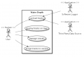
Datei:Water-depth.png Use case diagram for croud sourced depth data.(588 × 399 (28 KB)) - 20:30, 20. Sep. 2012
Datei:NASA Clipper I2C example byte num.svg Logic Analyser data of a NASA Clipper Depth I2C sentence.(900 × 450 (430 KB)) - 10:08, 19. Aug. 2014- In OpenSeaMap we use several DBs with harbour data and there are other DBs who are offered for use. | Recreation anchorage || wind protected area with appropriated depth7 KB (1.035 Wörter) - 17:06, 10. Mai 2018
- # numtiles16 is right now hardcoded at int-chart.gejson for ol depth of view reasons, there might be smarter ways in future // this is handy to quickly test what data is in an array14 KB (1.744 Wörter) - 13:01, 22. Jun. 2015
- | [[OpenSeaMap-dev:HW-logger/Depth sounder mobil]] | [[h:En:Upload NMEA-Data]]5 KB (530 Wörter) - 20:58, 13. Feb. 2023


Zeige (vorherige 20 | nächste 20) (20 | 50 | 100 | 250 | 500)