h:En:Marker in URL: Unterschied zwischen den Versionen
Markus (Diskussion | Beiträge) (Die Seite wurde neu angelegt: „{|border="0" cellpadding="6" cellspacing="0" width="100%" !style="background:#E3E3E3;" | Sprachen: !style="background:#E3E3E3;" | Deutsch…“) |
Markus (Diskussion | Beiträge) (→Add text) |
||
| Zeile 39: | Zeile 39: | ||
To do this, write the text to be displayed in the "Permalink" tool in the text window. | To do this, write the text to be displayed in the "Permalink" tool in the text window. | ||
<br> Allowed are letters and numbers (including umlauts, spaces and special characters). | <br> Allowed are letters and numbers (including umlauts, spaces and special characters). | ||
| − | + | ||
| − | + | HTML code is not allowed. | |
| − | + | ||
| − | + | :Exception: | |
| + | :{| class="wikitable" | ||
| + | ! What || Code | ||
| + | |- | ||
| + | | '''Bold''' || <code><nowiki><b>Bold</b></nowiki></code> | ||
| + | |- | ||
| + | | Line break || <code><Return></code> | ||
| + | |} | ||
The link will be automatically adjusted in the URL field after each change. | The link will be automatically adjusted in the URL field after each change. | ||
Version vom 22. März 2018, 07:57 Uhr
| Sprachen: | Deutsch | English |
|---|
Please improve the English translation...
By the tool Marker in URL you can save the current state of the full screen map as a URL and pass it to third parties. The center of the image, the selected zoom level, and the activated layers are saved. In addition, a marker and a descriptive text about the marker can be saved.
The URL can be sent by e-mail, or linked to websites.
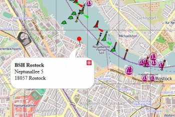
When the user opens this link, he sees the same chart section: size of the section, center of the chart, zoom level, view of the layers, the marker in the correct position, and clicking on the marker will bring up a description text pop up.
Inhaltsverzeichnis
Open the permalink tool
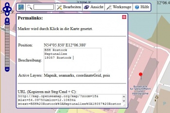
Open the tool "Permalink" in the menu "Tools".
At the bottom you can always see your current link in the "URL" field.
After clicking in the field, it is marked and can be copied to the clipboard (eg press [Strg] + [C])
Set a Marker
To mark a specific position, you can set a marker.
As long as the tool "Permalink" is open, you can mark a position by clicking on the map.
The further you zoom in, the more accurate you can position the marker.
Then zoom out again to select the pass map section.
Each additional click restores the marker.
The link will be automatically adjusted in the URL field after each change.
Add text
You can add a text that will be displayed at the marker in a speech bubble.
To do this, write the text to be displayed in the "Permalink" tool in the text window.
Allowed are letters and numbers (including umlauts, spaces and special characters).
HTML code is not allowed.
- Exception:
What Code Bold <b>Bold</b>Line break <Return>
The link will be automatically adjusted in the URL field after each change.
Determine map section
Slide and zoom the map until you see the matching neckline.
The link is automatically adjusted in the URL text area after each change.
Select layers
The layers can be arbitrarily selected and put together.
The link will be automatically adjusted in the URL field after each change.
Permalink without marker
To get a permaink without markers, there is a faster way:
- Select the map section at the desired zoom level and the layers to be displayed.
- Click on "Permalink" in the lower right corner of the map.
- Now in the address bar of the browser is now your link.
You can right-click the permalink on the bottom right (copy the link address)
or in the browser in the address bar with "mark everything" (<Ctrl-a> and <Ctrl-c>)
copy into the Zwischenanblage (dashboard?).
Workaround for a marker without text
A bug in the tool prevents a marker from being displayed without text.
Here is a quick workaround:
- Markers visible
- http://map.openseamap.org/?zoom=12&lat=54.153&lon=11.654&mlat=54.19420&mlon=11.64748&layers=BTTFFFTFFTF0FFFFFFFFFF
- Hidden marker
- http://map.openseamap.org/?zoom=12&lat=54.153&lon=11.654&mlat=54.19420&mlon=11.64748&layers=BFTFFFTFFTF0FFFFFFFFFF
The difference lies in the 2nd position in the layer string. (T vs F)

