OruxMaps: Unterschied zwischen den Versionen
Markus (Diskussion | Beiträge) (Die Seite wurde neu angelegt: „{|border="0" cellpadding="6" cellspacing="0" width="100%" !style="background:#E3E3E3;" | Deutsch !style="background:#E3E3E3;" | [[OruxMaps|Engl…“) |
(kein Unterschied)
|
Version vom 24. Juli 2013, 10:50 Uhr
| Deutsch | English |
|---|
OruxMaps shows OpenSeaMap on Android tablets as online and offline charts (by cache).
The navigation software shows the ship position, GPS data. Routing on roads.
Alternatively to the internal GPS an external GPS can be used via Bluetooth.
Inhaltsverzeichnis
Download
Select chart
Works with Version 5.6
OpenSeaMap kannst Du einfach aus der Kartenliste auswählen.
Bei jedem Betrachten wird die aktuelle Ansicht im Cache gespeichert.
Diese Kacheln sind dann auch offline verfügbar.
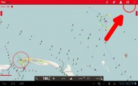
| 1. | Oben rechts auf Karten-Symbol klicken Es offnet sich eine Menü-Liste. | |
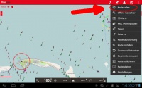
| 2. | Auf "Karte laden" klicken. Es erscheint links eine Liste. | |
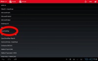
| 3. | Wähle OpenSeaMap (in der Liste nach unten scrollen). |
Split-Screen
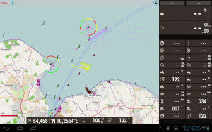
Like a chart plotter OruxMaps shows the Nautical chart at left, and the navigation data at right.
The layout of the data display is editable.
Context sensitive menus on top, bottom and side can be showed on demand.
Waypoints and routes sind möglich.
By the WLAN-Logger you can transmit navigation data from the ships electronic via WLAN to the Android tablet. OruxMaps shows the navigation data directly on the chart: course, speed, wind, waterdepth, position, etc.
This works with all devices using WLAN.
Logging Waterdephts
The WLAN-Logger can directly log waterdepths.


