OpenSeaMap-dev:Splitscreen: Unterschied zwischen den Versionen
Markus (Diskussion | Beiträge) (Die Seite wurde neu angelegt: „Mobile apps needs a split screen: : Chart at left side : Navigation data at right side For an optimal workflow, we need a specific userfriendly "look and feel"…“) |
Markus (Diskussion | Beiträge) |
||
| Zeile 1: | Zeile 1: | ||
| + | [[Datei:Splitscreen-and-Menu.jpg|right|300px]] | ||
Mobile apps needs a split screen: | Mobile apps needs a split screen: | ||
: Chart at left side | : Chart at left side | ||
| Zeile 17: | Zeile 18: | ||
| SOG || 1 || x || || speed over ground || Geschwindigkeit über Grund || | | SOG || 1 || x || || speed over ground || Geschwindigkeit über Grund || | ||
|- | |- | ||
| − | | DBS || 1 || x || || depth below surface || Tiefe unter Wasserspiegel || | + | | DBS || 1 || x || || depth below surface || Tiefe unter Wasserspiegel || alternative DBT |
|- | |- | ||
| ETA || 1 || x || || estimated time of arrival || Ankunftszeit || | | ETA || 1 || x || || estimated time of arrival || Ankunftszeit || | ||
| Zeile 47: | Zeile 48: | ||
| || 4 || || x || time to next waypoint || Zeit bis nächster WP || | | || 4 || || x || time to next waypoint || Zeit bis nächster WP || | ||
|} | |} | ||
| + | |||
| + | == Ship position == | ||
| + | [[Datei:Ship-Cursor.gif|thumb|Ship-cursor]] | ||
| + | A ship-cursor shows the position in the center of the chart. | ||
| + | <br>When the ship is not in motion, the cursor switch to a standard-cursor (or to another colour). | ||
| + | <br>Ship-cursor directed to the course. | ||
| + | <br>Dashed line marks the stearing yourse (optional switch off/on). | ||
== Cursor == | == Cursor == | ||
| − | Rubber band cursor from ship position | + | [[Datei:Rubberband-Cursor.gif.jpg|thumb|Rubberband-Cursor]] |
| − | <br>with display of course and distance from | + | Rubber band cursor from ship position |
| + | <br>with crosshair-cursor | ||
| + | <br>display of course and distance from ship position to cursor, | ||
<br>and coordinate of cursor (copy of coordinate to clipboard). | <br>and coordinate of cursor (copy of coordinate to clipboard). | ||
| + | |||
| + | == Measuring tool == | ||
| + | 1. set a starting point | ||
| + | <br>2. move the crosshair-cursor (works like rubberband-cursor) | ||
| + | <br>setting a target point keeps the line on the chart | ||
== Menu == | == Menu == | ||
| − | Menu button on bottom at left side | + | Menu button on bottom at left side corner |
<br>Context sensitive menu on left side | <br>Context sensitive menu on left side | ||
<br> Context sensitive menu on bottom | <br> Context sensitive menu on bottom | ||
Version vom 18. Juli 2013, 08:06 Uhr
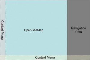
Mobile apps needs a split screen:
- Chart at left side
- Navigation data at right side
For an optimal workflow, we need a specific userfriendly "look and feel" for chart, nav data and menu.
Inhaltsverzeichnis
Chart
Split screen left side, 80%
Split screen right side, 20%
| data | prio | Nav | WPT | en | de | remarks |
|---|---|---|---|---|---|---|
| COG | 1 | x | course over ground | Kurs über Grund | ||
| SOG | 1 | x | speed over ground | Geschwindigkeit über Grund | ||
| DBS | 1 | x | depth below surface | Tiefe unter Wasserspiegel | alternative DBT | |
| ETA | 1 | x | estimated time of arrival | Ankunftszeit | ||
| XTE | 1 | x | cross track error | Kursabweichung [m] | ||
| ETE | 2 | x | estimated time of elapsed | Zeit bis Ankunft | ||
| AWS | 2 | x | apparent wind speed | Scheinbare Windgescheindigkeit | ||
| AWA | 2 | x | apparent wind angle | Scheinbare Windrichtung | ||
| VMG | 2 | x | velocity made good | Geschwindigkeit zum Ziel | ||
| SAT | 3 | x | ||||
| LOG | 3 | x | status of NMEA-logging | Betriebszustand des NMEA-Loggers | ein / aus / ... | |
| HDOP | 4 | x | horizontal dilution of precision | |||
| TWS | 4 | x | true wind speed | Windgeschwindigkeit wahr | ||
| TWA | 4 | x | true wind angle | Windrichtung wahr | ||
| 4 | x | course to next waypoint | Kurs bis nächster WP | |||
| 4 | x | distance to next waypoint | Distanz bis nächster WP | |||
| 4 | x | time to next waypoint | Zeit bis nächster WP |
Ship position
A ship-cursor shows the position in the center of the chart.
When the ship is not in motion, the cursor switch to a standard-cursor (or to another colour).
Ship-cursor directed to the course.
Dashed line marks the stearing yourse (optional switch off/on).
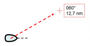
Cursor
Rubber band cursor from ship position
with crosshair-cursor
display of course and distance from ship position to cursor,
and coordinate of cursor (copy of coordinate to clipboard).
Measuring tool
1. set a starting point
2. move the crosshair-cursor (works like rubberband-cursor)
setting a target point keeps the line on the chart
Menu
Menu button on bottom at left side corner
Context sensitive menu on left side
Context sensitive menu on bottom
- Splitscreen with chart and Navi-data
- Search
- Rubber band cursor with cursor context menu
Goto
- Goto Cursor (virual Waypoint)
- Goto Waypoint (from list)
- use Route
Waypoints
- set and name Waypoints
- edit Waypoints
- delete Waypoints
Route
- set and name Routes
- add Waypoints to Routes
- set and name Waypoints
- edit Routes
- delete Routes
Settings
- Units
- dd,ddd° | dd°mm,m'
- nm | km
- UTC | local time
- Path
- for Maps
- for NMEA-Logfiles
- for Waypoints and Routes
- Logger
- on | off
- start new file
- Display
- Navigation (which data to display)
- Chart (North-up | Head-up)
- Layers (AIS, Radar, Fish-Finder, etc)


