h:En:Measuring Strategy: Unterschied zwischen den Versionen
Markus (Diskussion | Beiträge) (Die Seite wurde neu angelegt: „{|border="0" cellpadding="6" cellspacing="0" width="100%" !style="background:#E3E3E3;" | Deutsch !style="background:#E3E3E3;" | [[Measuri…“) |
Markus (Diskussion | Beiträge) |
||
| (7 dazwischenliegende Versionen von 2 Benutzern werden nicht angezeigt) | |||
| Zeile 1: | Zeile 1: | ||
{|border="0" cellpadding="6" cellspacing="0" width="100%" | {|border="0" cellpadding="6" cellspacing="0" width="100%" | ||
| − | !style="background:#E3E3E3;" | [[ | + | !style="background:#E3E3E3;" | [[h:De:Mess-Strategie|Deutsch]] |
| − | !style="background:#E3E3E3;" | [[Measuring Strategy|English]] | + | !style="background:#E3E3E3;" | [[h:En:Measuring Strategy|English]] |
!style="background:#E3E3E3; width:100%;" | | !style="background:#E3E3E3; width:100%;" | | ||
|} | |} | ||
| Zeile 7: | Zeile 7: | ||
{{Vorlage:Water_depth}} | {{Vorlage:Water_depth}} | ||
| − | + | Simply measure where you are at the moment. <br> | |
| + | There is nothing special to do :-) <br> | ||
| + | Switch on the logger before you sail off<br> | ||
| + | and let it run for another half an hour after you have arrived. | ||
| − | |||
| − | + | == Systematic Collection== | |
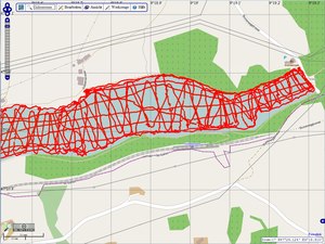
| − | + | [[File:Wassertiefen Gübsensee 2013-10-11 z17 4x3.tif|thumb|[http://map.openseamap.org/?zoom=17&layers=BFTTFFTFFTF0FFFFFTFF&lang=de&lat=47.39867&lon=9.31404 Systematic Collection] ]] | |
| − | |||
| − | |||
| − | + | We recommend to collect the data of your home port and the approach to the port systematically. | |
| − | + | Systematic collection is also advisable for anchorage bays, beaches, and buoy fields. | |
| − | |||
| − | |||
| − | |||
| − | |||
| − | |||
; Important | ; Important | ||
| − | : | + | : navigate as close to the shore as your draft allows |
| − | : | + | : navigate as close to any shoal as your draft allows |
| − | : | + | : sail parallel lines in a distance of 10..50m |
| − | : | + | : mark shoals on the map |
| − | == Chaotic | + | == Chaotic Collection == |
| − | [[File:Wassertiefen-per-Crowdsourcing chaotisch z18.jpg|thumb|[http://map.openseamap.org/?zoom=18&layers=BFTFFFTFFTF0FFFFFTFF&lang=de&lat=48.91938&lon=8.17901 Chaotic | + | [[File:Wassertiefen-per-Crowdsourcing chaotisch z18.jpg|thumb|[http://map.openseamap.org/?zoom=18&layers=BFTFFFTFFTF0FFFFFTFF&lang=de&lat=48.91938&lon=8.17901 Chaotic Collection] ]] |
| − | In | + | In areas, where many skippers are on the way (for example at the fuel station in Palma, Mallorca), there will automatically be a dense collection of data by crowdsourcing. On the periphery of heavily frequenced ways, the density of measuring points is of course lower. In those cases of lower density, it helps to measure more [[#Systematic Collection|systematically]]. |
| − | + | If you are at a mooring place, pier, or if you sway at anchor, don´t turn the logger off, so that a point cloud can develop. This helps us to calibrate the data. | |
<gallery> | <gallery> | ||
| − | File:Palma-z-19.jpg|[http://map.openseamap.org/?zoom=18&layers=BFTFFFTFFTF0FFFFFTFF&lang=de&lat=39.56436&lon=2.63404 | + | File:Palma-z-19.jpg|[http://map.openseamap.org/?zoom=18&layers=BFTFFFTFFTF0FFFFFTFF&lang=de&lat=39.56436&lon=2.63404 Filling station in Palma] |
GPS-Genauigkeit yx-Abweichung.jpg|Point cloud | GPS-Genauigkeit yx-Abweichung.jpg|Point cloud | ||
</gallery> | </gallery> | ||
| − | == | + | == Collection under way == |
| − | [[File:OpenSeaMap-Kunst.jpg|thumb|[http://map.openseamap.org/?zoom=17&lat=52.26679&lon=11.78631&mlat=52.26861&mlon=11.78343&mtext=%3Cb%3EOpenSeaMap%20-%20Kunst%3C%2Fb%3E&layers=BTTFFFTFFTF0FFFFFTFFFF OpenSeaMap | + | [[File:OpenSeaMap-Kunst.jpg|thumb|[http://map.openseamap.org/?zoom=17&lat=52.26679&lon=11.78631&mlat=52.26861&mlon=11.78343&mtext=%3Cb%3EOpenSeaMap%20-%20Kunst%3C%2Fb%3E&layers=BTTFFFTFFTF0FFFFFTFFFF OpenSeaMap art] ]] |
| − | + | Sail your trip as usual. <br> | |
| − | + | Your track will be recorded automatically :-) | |
| − | + | You can optimize the result: | |
| − | * | + | * navigate '''as close to the shore''' as your draft allows, <br>also when you are '''tacking''' |
| − | * | + | * navigate in a '''circle around a shoal''' as tight as possible <br> and a second circle a little bit further <br> and if possible, also sail through two shoals |
| − | * | + | * especially interesting are '''ports, bays, capes''', <br> passages through islands, and approaches.<br> So, if such a site is on your way: take it! |
| − | * | + | * perform many '''manoeuvres in shallow water''' |
| − | * ''' | + | * '''tack once in a while under motor''' in shallow water |
| − | + | Sometimes, an extra detour is an easy way to help ... | |
| − | + | To cover interesting sites systematically (go around the port, looking for an anchoring place, go between buoys and anchoring ships) <br> | |
| − | + | navigate as close to the shore and to shoals as your draft allows. <br> | |
| − | + | Tacking and manoeuvres help to collect a broad track. | |
| − | + | The most important data are those '''between 2 and 10m'''. <br> | |
| − | + | We analyse all data between 0 and 100m (200m). | |
| − | == | + | == Collection by Dinghy == |
| − | [[Datei:Tender_Galeb.jpg|thumb| | + | [[Datei:Tender_Galeb.jpg|thumb|Mobil measuring system]] |
| − | + | With a [[OpenSeaMap-dev:HW-logger/Tiefenmesser_mobil|dinghy, with mobile GPS and sounder]], you can measure very shallow banks. This is perfect for ports and anchorage bays. Children and teens love to use laytimes for such rubber boat trips! | |
| − | == About Technique == | + | == About the Technique == |
* http://depth.openseamap.org/#introduction | * http://depth.openseamap.org/#introduction | ||
| − | * | + | * Further pages in the Wiki: see box in the upper right corner |
Version vom 28. Januar 2021, 15:28 Uhr
| Deutsch | English |
|---|
| Water depth |
|---|
| Depth-Website |
| The project |
| Measuring strategy |
| Upload NMEA-data |
| Metadata help |
| Connecting NMEA-Logger |
| Hardware Logger |
| Software Logger |
| Mobile sounder |
| Ship network |
| Data formats |
Simply measure where you are at the moment.
There is nothing special to do :-)
Switch on the logger before you sail off
and let it run for another half an hour after you have arrived.
Inhaltsverzeichnis
Systematic Collection
We recommend to collect the data of your home port and the approach to the port systematically. Systematic collection is also advisable for anchorage bays, beaches, and buoy fields.
- Important
- navigate as close to the shore as your draft allows
- navigate as close to any shoal as your draft allows
- sail parallel lines in a distance of 10..50m
- mark shoals on the map
Chaotic Collection

In areas, where many skippers are on the way (for example at the fuel station in Palma, Mallorca), there will automatically be a dense collection of data by crowdsourcing. On the periphery of heavily frequenced ways, the density of measuring points is of course lower. In those cases of lower density, it helps to measure more systematically.
If you are at a mooring place, pier, or if you sway at anchor, don´t turn the logger off, so that a point cloud can develop. This helps us to calibrate the data.
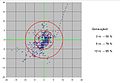
Point cloud


Collection under way

Sail your trip as usual.
Your track will be recorded automatically :-)
You can optimize the result:
- navigate as close to the shore as your draft allows,
also when you are tacking - navigate in a circle around a shoal as tight as possible
and a second circle a little bit further
and if possible, also sail through two shoals - especially interesting are ports, bays, capes,
passages through islands, and approaches.
So, if such a site is on your way: take it! - perform many manoeuvres in shallow water
- tack once in a while under motor in shallow water
Sometimes, an extra detour is an easy way to help ...
To cover interesting sites systematically (go around the port, looking for an anchoring place, go between buoys and anchoring ships)
navigate as close to the shore and to shoals as your draft allows.
Tacking and manoeuvres help to collect a broad track.
The most important data are those between 2 and 10m.
We analyse all data between 0 and 100m (200m).
Collection by Dinghy

With a dinghy, with mobile GPS and sounder, you can measure very shallow banks. This is perfect for ports and anchorage bays. Children and teens love to use laytimes for such rubber boat trips!
About the Technique
- http://depth.openseamap.org/#introduction
- Further pages in the Wiki: see box in the upper right corner