h:En:Gauges: Unterschied zwischen den Versionen
Markus (Diskussion | Beiträge) (Die Seite wurde neu angelegt: „{|border="0" cellpadding="6" cellspacing="0" width="100%" !style="background:#E3E3E3;" | Deutsch !style="background:#E3E3E3;" | h:en:Gauges|En…“) |
Markus (Diskussion | Beiträge) |
||
| Zeile 7: | Zeile 7: | ||
[[Image:Ilmpegel_Ilmenau.JPG|thumb]] | [[Image:Ilmpegel_Ilmenau.JPG|thumb]] | ||
| − | + | Water level gauging stations measure the height of the water level of seas, rivers and lakes. | |
| − | Tide gauge data are an important reference quantity for measuring water depth, for recording high and low tides, for assessing flow velocities, navigability of waterways, navigability of white water stretches, for early detection of flood danger. Therefore they are dynamically displayed in OpenSeaMap. | + | [[wikipedia:en:Tide gauge|Tide gauge]] and [[wikipedia:en:Stream gauge|Steam gauge]] data are an important reference quantity for measuring water depth, for recording high and low tides, for assessing flow velocities, navigability of waterways, navigability of white water stretches, for early detection of flood danger. Therefore they are dynamically displayed in OpenSeaMap. |
== Gauges in OpenSeaMap == | == Gauges in OpenSeaMap == | ||
Aktuelle Version vom 27. Mai 2021, 06:13 Uhr
| Deutsch | English |
|---|

Water level gauging stations measure the height of the water level of seas, rivers and lakes.
Tide gauge and Steam gauge data are an important reference quantity for measuring water depth, for recording high and low tides, for assessing flow velocities, navigability of waterways, navigability of white water stretches, for early detection of flood danger. Therefore they are dynamically displayed in OpenSeaMap.
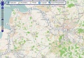
Gauges in OpenSeaMap
OpenSeaMap displays gauge locations in a layer.
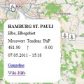
The icons are clickable, in a popup are displayed:
- static gauge data (name, water body, area, gauge zero).
- dynamic water level data (water level, tendency, date and time of measurement)
A link shows for each gauge:
- the current hydrograph
- a meteogram with current weather data
Chart
Data
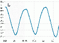
Hydrograph


Attributes
- Dynamic attributes
- Measured value (mm)
- Date Time
- Tendency
- Error message (for possible errors during transmission)
- Static attributes
- GK coordinates
- Name
- Gauge number
- Level zero point (PnP) (m)
- Strip zone
- Reference system
- Ellipsoid
- Latitude (calculated)
- Longitude (calculated)