OpenSeaMap-dev:Depth-Ocean Melt Greenland: Unterschied zwischen den Versionen
Markus (Diskussion | Beiträge) K (Markus verschob Seite OpenSeaMap-dev:Depth - OMG nach OpenSeaMap-dev:Depth-OMG) |
Markus (Diskussion | Beiträge) K (Markus verschob die Seite OpenSeaMap-dev:Depth-OMG nach OpenSeaMap-dev:Depth-Ocean Melt Greenland, ohne dabei eine Weiterleitung anzulegen) |
||
| (3 dazwischenliegende Versionen desselben Benutzers werden nicht angezeigt) | |||
| Zeile 9: | Zeile 9: | ||
== Involved persons == | == Involved persons == | ||
| − | Nolwenn | + | : Nolwenn Chauche <nolwennchauche@gmail.com> (1.2.2016-16.7.2017) |
| + | : Markus | ||
== Data == | == Data == | ||
| Zeile 32: | Zeile 33: | ||
== Software needed == | == Software needed == | ||
* [[wikipedia:de:QGIS|QGIS]] | * [[wikipedia:de:QGIS|QGIS]] | ||
| − | * [[wikipedia:de:Matlab|Matlab]] (proprietary) | + | * [[wikipedia:de:Matlab|Matlab]] (proprietary) <br>or Octave or Python (with Matlib) |
| + | * [[wikipedia:de:ArcGIS|ArcGIS]] (ESRI, proprietary) - for making contour lines | ||
== Pictures == | == Pictures == | ||
| Zeile 41: | Zeile 43: | ||
Datei:Greenland, administrative divisions - de - colored.svg | administrative | Datei:Greenland, administrative divisions - de - colored.svg | administrative | ||
</gallery> | </gallery> | ||
| + | |||
| + | |||
| + | [[Category:Depth]] | ||
| + | [[Category:Import]] | ||
Aktuelle Version vom 10. November 2023, 01:06 Uhr

This is the documentation for the integration of bathymetric data donations from Ocean Melt Greenland (OMG) into OpenSeaMap.
Inhaltsverzeichnis
Project
- Ocean Melt Greenland (OMG)
- National Snow & Ice Data Center (NSIDC)
- Area: Greenland
Involved persons
- Nolwenn Chauche <nolwennchauche@gmail.com> (1.2.2016-16.7.2017)
- Markus
Data
- Grid 150 x 150 m
- 2GB (compressed in NetCDF format)
Projection
| Project | EPSG | Remarks |
|---|---|---|
| OMG | EPSG 3413 | description |
| OpenSeaMap | EPSG 3857 | description |
Servers
Software needed
- QGIS
- Matlab (proprietary)
or Octave or Python (with Matlib) - ArcGIS (ESRI, proprietary) - for making contour lines
Pictures
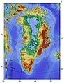
WP-Commons
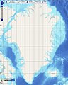
OpenSeaMap GEBCO
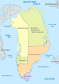
administrative

